
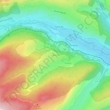
La Bastide topographic map
Interactive map
Click on the map to display elevation.
About this map
Name: La Bastide topographic map, elevation, terrain.
Average elevation: 1,111 m
Minimum elevation: 888 m
Maximum elevation: 1,467 m
Other topographic maps
Click on a map to view its topography, its elevation and its terrain.
Fraisse Bas
France > Auvergne-Rhône-Alpes > Cantal > Laveissière
Fraisse Bas, Laveissière, Saint-Flour, Cantal, Auvergne-Rhône-Alpes, France métropolitaine, 15300, France
Average elevation: 1,101 m
Fraisse-Haut
France > Auvergne-Rhône-Alpes > Cantal > Laveissière
Fraisse-Haut, Laveissière, Saint-Flour, Cantal, Auvergne-Rhône-Alpes, France métropolitaine, 15300, France
Average elevation: 1,233 m