
El Calafate topographic map
Interactive map
Click on the map to display elevation.
About this map
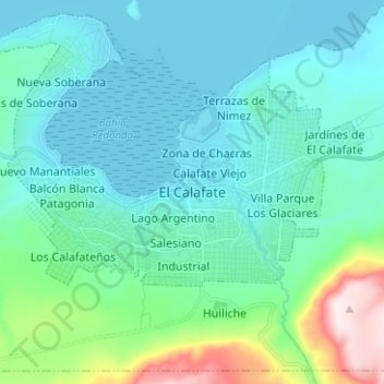
Name: El Calafate topographic map, elevation, terrain.
Location: El Calafate, Lago Argentino, Santa Cruz, 9405, Argentina (-50.37887 -72.31208 -50.29887 -72.23208)
Average elevation: 296 m
Minimum elevation: 177 m
Maximum elevation: 879 m
Other topographic maps
Click on a map to view its topography, its elevation and its terrain.
Balcón del Aeropuerto
Argentina > Santa Cruz > El Calafate
Balcón del Aeropuerto, El Calafate, Municipio de El Calafate, Lago Argentino, Santa Cruz, Argentina
Average elevation: 235 m