
Thank you for supporting this site ❤️
Make a donation
Make a donation
Wehrshausen topographic map
Click on the map to display elevation.
Thank you for supporting this site ❤️
Make a donation
Make a donation
Wehrshausen
Wehrshausen liegt rund 3 km westlich der Kernstadt von Marburg am westlichen Hang des Marburger Rückens in waldreicher Umgebung. Unmittelbar östlich des Ortes verlief auf dem Höhenrücken die Weinstraße (Wagenstraße) als mittelalterliche Handelsstraße.
Thank you for supporting this site ❤️
Make a donation
Make a donation
About this map
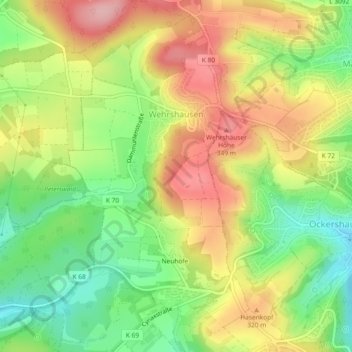
Name: Wehrshausen topographic map, elevation, terrain.
Average elevation: 281 m
Minimum elevation: 205 m
Maximum elevation: 362 m
Thank you for supporting this site ❤️
Make a donation
Make a donation
Other topographic maps
Click on a map to view its topography, its elevation and its terrain.
Dilschhausen
Deutschland > Hessen > Landkreis Marburg-Biedenkopf > Marburg > Dilschhausen
Average elevation: 301 m