
Thank you for supporting this site ❤️
Make a donation
Make a donation
Dobra Voda topographic map
Click on the map to display elevation.
Thank you for supporting this site ❤️
Make a donation
Make a donation
About this map
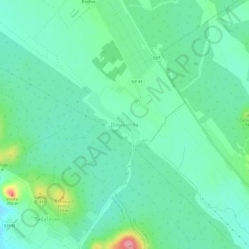
Name: Dobra Voda topographic map, elevation, terrain.
Location: Dobra Voda, Comitat de Zadar, Croatie (43.91032 15.63025 43.95032 15.67025)
Average elevation: 161 m
Minimum elevation: 130 m
Maximum elevation: 257 m
Thank you for supporting this site ❤️
Make a donation
Make a donation
Other topographic maps
Click on a map to view its topography, its elevation and its terrain.