
Thank you for supporting this site ❤️
Make a donation
Make a donation
Carrio topographic map
Click on the map to display elevation.
Thank you for supporting this site ❤️
Make a donation
Make a donation
About this map
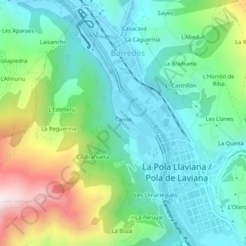
Name: Carrio topographic map, elevation, terrain.
Location: Carrio, Laviana, Asturias, Spain (43.24036 -5.59585 43.26355 -5.56573)
Average elevation: 442 m
Minimum elevation: 267 m
Maximum elevation: 882 m
Thank you for supporting this site ❤️
Make a donation
Make a donation
Other topographic maps
Click on a map to view its topography, its elevation and its terrain.