
Thank you for supporting this site ❤️
Make a donation
Make a donation
Choondal topographic map
Click on the map to display elevation.
Thank you for supporting this site ❤️
Make a donation
Make a donation
About this map
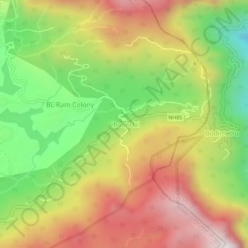
Name: Choondal topographic map, elevation, terrain.
Location: Choondal, Udumbanchola, Idukki, Kerala, India (10.00129 77.22853 10.04129 77.26853)
Average elevation: 1,414 m
Minimum elevation: 894 m
Maximum elevation: 1,941 m
Thank you for supporting this site ❤️
Make a donation
Make a donation
Other topographic maps
Click on a map to view its topography, its elevation and its terrain.
Thank you for supporting this site ❤️
Make a donation
Make a donation
Thank you for supporting this site ❤️
Make a donation
Make a donation