
Make a donation
Highland topographic map
Click on the map to display elevation.
Make a donation
Highland
The majority of the downtown Highland district is situated within the 418-acre (169 ha) land grant named "Hickory Ridge". The Rouse Company borrowed the land grant name for one of its nearby villages of Columbia, built in 1974. The historic "White Hall" or "Hickory Ridge" estate (1749) was owned by the Ridgely, Hopkins and Disney families. One of the earliest businesses at the crossroads was Well's tavern, founded by Richard Wells in 1759. This was replaced with a wheelwright's shop by Joshua B. Disney in 1842. The same year, William Wall opened a general store and post office, giving the crossroads the short-lived name of "Walls Crossroads" before another name change of the post office on December 2, 1878, to "Highland" to reflect the town's elevation in Howard County. The County Commissioners added Hall Shop Road on the southern side of the community in 1877. The town did not receive direct rail service, but was only nine miles away from the B&O railroad in Laurel, Maryland using the rolling road now known as Route 216.
Make a donation
About this map
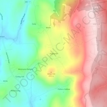
Name: Highland topographic map, elevation, terrain.
Location: Highland, Frederick County, Maryland, 21773, United States (39.50093 -77.53804 39.54093 -77.49804)
Average elevation: 357 m
Minimum elevation: 195 m
Maximum elevation: 532 m
Make a donation
Other topographic maps
Click on a map to view its topography, its elevation and its terrain.
Make a donation
Braddock Heights
United States > Maryland > Frederick County > Braddock Heights
Braddock Heights is located at an elevation of 950 feet (290 m) atop Braddock Mountain (as Catoctin Mountain is locally known) near the pass at Braddock Springs, so named after British General Edward Braddock and Lt. Colonel George Washington's use of the mountain pass on their way to Fort Duquesne during the…
Average elevation: 179 m
Make a donation
Make a donation
Make a donation
Make a donation
Make a donation
Make a donation