
Thank you for supporting this site ❤️
Make a donation
Make a donation
Tawar topographic map
Click on the map to display elevation.
Thank you for supporting this site ❤️
Make a donation
Make a donation
About this map
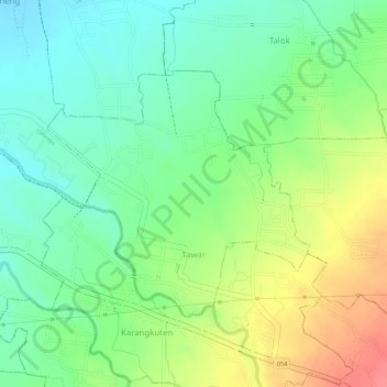
Name: Tawar topographic map, elevation, terrain.
Location: Tawar, Mojokerto, East Java, Java, Indonesia (-7.60494 112.44854 -7.58782 112.46706)
Average elevation: 117 m
Minimum elevation: 86 m
Maximum elevation: 161 m
Thank you for supporting this site ❤️
Make a donation
Make a donation
Other topographic maps
Click on a map to view its topography, its elevation and its terrain.
Thank you for supporting this site ❤️
Make a donation
Make a donation
Thank you for supporting this site ❤️
Make a donation
Make a donation
Mount Penanggungan
Indonesia > East Java > Mojokerto > Kedungudi
There are sub-peaks around Penanggungan, starting to the southeast from Mount Wangi (Gunung Wangi) at 970 meters above sea level, Mount Bekel Jolotundo elevated 1,200 meters ASL, a semi-freestanding peak to the northwest; Puncak Kemuncup rising to 1,200 meters on the eastern face, Puncak Sarah Klopo on the…
Average elevation: 1,061 m