
Formentera topographic map
Interactive map
Click on the map to display elevation.
About this map
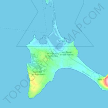
Name: Formentera topographic map, elevation, terrain.
Location: Formentera, Balearische Inseln, Spanien (38.64045 1.38013 38.77201 1.58486)
Average elevation: 7 m
Minimum elevation: -4 m
Maximum elevation: 192 m
Formentera verfügt über eine Küstenlinie von etwa 70 Kilometern Länge. Der höchste Punkt (la Talaiassa La Mola) liegt auf einer Höhe von 192 msnm. Das Klima ist mild mit einer Durchschnittstemperatur von 16,6 °C. Die Vegetation zeigt sich typisch mediterran und besteht, soweit nicht landwirtschaftlich genutzt, aus Wäldern von Pinie und Sadebaum.