
Make a donation
Murung Raya topographic map
Click on the map to display elevation.
Make a donation
Murung Raya
The regency has an area of 23,700 km2 and lies between 114°27'00 to 115°49'00 East longitude and 0°58'30 North latitude to 1°26'00 South latitude. It occupies the valleys and foothills of the southern and eastern slopes of the Müller Mountains, and rises to 1730 m at Mount Lesung on its northern border. Most of the riverine area lies at an altitude of 100 to 200 m above sea level while the foothills are mostly at an altitude of 400–500 m.
Make a donation
About this map
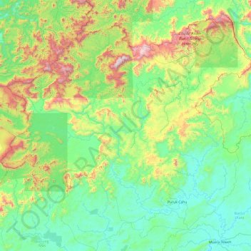
Name: Murung Raya topographic map, elevation, terrain.
Location: Murung Raya, Central Kalimantan, Kalimantan, Indonesia (-0.92849 113.21934 0.79101 115.13739)
Average elevation: 365 m
Minimum elevation: 16 m
Maximum elevation: 1,857 m
Make a donation
Other topographic maps
Click on a map to view its topography, its elevation and its terrain.
Make a donation
Make a donation
Make a donation
Puruk Cahu
Indonesia > Central Kalimantan > Murung Raya
Puruk Cahu is crossed by one of the most important rivers in Borneo, Barito River. This town is situated on a hilly land at the northeastern portion of Central Kalimantan. The altitude of this town is actually varied between 70 and 300 metres above sea level. Due to its proximity to the equator, Puruk Cahu…
Average elevation: 46 m
Make a donation
Make a donation
Make a donation
Make a donation
Bukit Baka Bukit Raya National Park
Indonesia > Central Kalimantan > Katingan
Average elevation: 307 m
Make a donation
Tanjung Puting National Park
Indonesia > Central Kalimantan > West Kotawaringin
Average elevation: 8 m
Make a donation
Make a donation