
Thank you for supporting this site ❤️
Make a donation
Make a donation
Karaka Island topographic map
Click on the map to display elevation.
Thank you for supporting this site ❤️
Make a donation
Make a donation
About this map
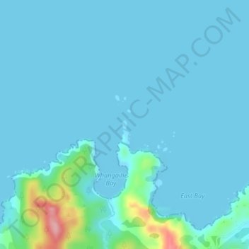
Name: Karaka Island topographic map, elevation, terrain.
Location: Karaka Island, Northland, New Zealand (-34.99073 173.81778 -34.98972 173.81857)
Average elevation: 13 m
Minimum elevation: 0 m
Maximum elevation: 140 m
Thank you for supporting this site ❤️
Make a donation
Make a donation
Other topographic maps
Click on a map to view its topography, its elevation and its terrain.
Te Haumi
New Zealand > Northland > Far North District > Bay of Islands-Whangaroa Community > Paihia
Average elevation: 34 m
Tōtara North
New Zealand > Northland > Far North District > Bay of Islands-Whangaroa Community
Average elevation: 67 m
Thank you for supporting this site ❤️
Make a donation
Make a donation
Kerikeri Inlet
New Zealand > Northland > Far North District > Bay of Islands-Whangaroa Community
Average elevation: 15 m
Kerikeri
New Zealand > Northland > Far North District > Bay of Islands-Whangaroa Community
Average elevation: 76 m
Thank you for supporting this site ❤️
Make a donation
Make a donation