
Thank you for supporting this site ❤️
Make a donation
Make a donation
Nagelfluhkette topographic map
Click on the map to display elevation.
Thank you for supporting this site ❤️
Make a donation
Make a donation
About this map
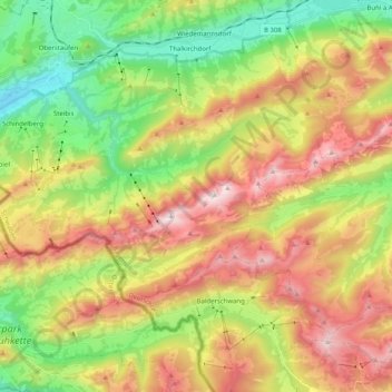
Name: Nagelfluhkette topographic map, elevation, terrain.
Average elevation: 1,160 m
Minimum elevation: 638 m
Maximum elevation: 1,818 m
Thank you for supporting this site ❤️
Make a donation
Make a donation
Other topographic maps
Click on a map to view its topography, its elevation and its terrain.
Buchenegger Wasserfälle
Deutschland > Bayern > Landkreis Oberallgäu > Oberstaufen
Average elevation: 923 m
Thank you for supporting this site ❤️
Make a donation
Make a donation