
Ratingen topographic map
Interactive map
Click on the map to display elevation.
About this map
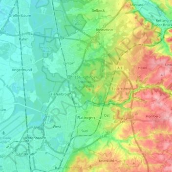
Name: Ratingen topographic map, elevation, terrain.
Location: Ratingen, Kreis Mettmann, Rhénanie-du-Nord-Westphalie, Allemagne (51.26453 6.80124 51.37179 6.98309)
Average elevation: 71 m
Minimum elevation: 27 m
Maximum elevation: 168 m
Other topographic maps
Click on a map to view its topography, its elevation and its terrain.
Hilden
Allemagne > Rhénanie-du-Nord-Westphalie > Kreis Mettmann
Hilden, Kreis Mettmann, Rhénanie-du-Nord-Westphalie, Allemagne
Average elevation: 55 m