
Chanly topographic map
Interactive map
Click on the map to display elevation.
About this map
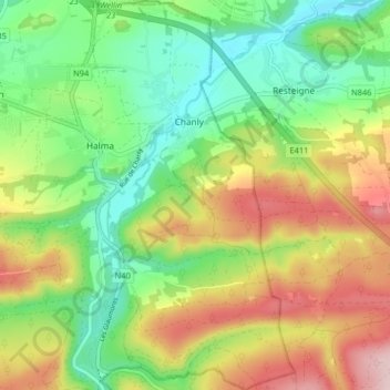
Name: Chanly topographic map, elevation, terrain.
Average elevation: 277 m
Minimum elevation: 173 m
Maximum elevation: 428 m
Other topographic maps
Click on a map to view its topography, its elevation and its terrain.
Wellin
Belgique > Luxembourg > Neufchâteau > Wellin
Wellin, Neufchâteau, Luxembourg, Wallonie, 6920, Belgique
Average elevation: 293 m
Wellin
Belgique > Luxembourg > Neufchâteau > Wellin
Wellin, Neufchâteau, Luxembourg, Wallonie, 6920, Belgique
Average elevation: 255 m
Lomprez
Belgique > Luxembourg > Neufchâteau > Wellin
Lomprez, Wellin, Neufchâteau, Luxembourg, Wallonie, 6924, Belgique
Average elevation: 306 m