
Palatine Hill topographic map
Interactive map
Click on the map to display elevation.
About this map
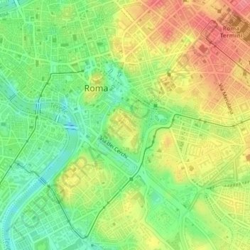
Name: Palatine Hill topographic map, elevation, terrain.
Average elevation: 40 m
Minimum elevation: 3 m
Maximum elevation: 79 m
In 2007 the legendary Lupercal cave was claimed to have been found beneath the remains of the Domus Livia (House of Livia) on the Palatine. Archaeologists came across the 16-metre-deep cavity while restoring the decaying palace, with a richly decorated vault encrusted with mosaics and seashells. The Lupercal was probably converted to a sanctuary by Romans in later centuries. Many others have denied its identification with the Lupercal on topographic and stylistic grounds, and believe that the grotto is actually a nymphaeum or underground triclinium from Neronian times.
Other topographic maps
Click on a map to view its topography, its elevation and its terrain.
Casal Monastero
Italy > Lazio > Roma Capitale > Rome
Casal Monastero, Rome, Roma Capitale, Lazio, 00131, Italy
Average elevation: 41 m
Infernetto
Italy > Lazio > Roma Capitale > Rome
Infernetto, Rome, Roma Capitale, Lazio, 00124, Italy
Average elevation: 25 m
Fontana di piazza dell'Aracoeli
Italy > Lazio > Roma Capitale > Rome
Fontana di piazza dell'Aracoeli, Campitelli, Municipio Roma I, Rome, Roma Capitale, Lazio, Italy
Average elevation: 39 m