
Alones topographic map
Interactive map
Click on the map to display elevation.
About this map
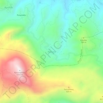
Name: Alones topographic map, elevation, terrain.
Average elevation: 691 m
Minimum elevation: 336 m
Maximum elevation: 1,296 m
Other topographic maps
Click on a map to view its topography, its elevation and its terrain.
Atsipopoulo
Greece > Region of Crete > Rethymno Regional Unit
Atsipopoulo, Municipality of Rethymnon, Rethymno Regional Unit, Region of Crete, 741 32, Greece
Average elevation: 143 m
Preveli Palmbeach
Greece > Region of Crete > Rethymno Regional Unit
Preveli Palmbeach, Municipality of Agios Vasileios, Rethymno Regional Unit, Region of Crete, Greece
Average elevation: 86 m
Rethymno
Greece > Region of Crete > Rethymno Regional Unit > Rethymno
Rethymno, Municipality of Rethymnon, Rethymno Regional Unit, Region of Crete, 741 31, Greece
Average elevation: 204 m
Gerani
Greece > Region of Crete > Rethymno Regional Unit > Gerani
Gerani, Municipality of Rethymnon, Rethymno Regional Unit, Region of Crete, Greece
Average elevation: 126 m
Plakias
Greece > Region of Crete > Rethymno Regional Unit
Plakias, Municipality of Agios Vasileios, Rethymno Regional Unit, Region of Crete, 740 60, Greece
Average elevation: 123 m
Agia Galini
Greece > Region of Crete > Rethymno Regional Unit > Agia Galini
Agia Galini, Municipality of Agios Vasileios, Rethymno Regional Unit, Region of Crete, 74056, Greece
Average elevation: 127 m
Vlichada
Greece > Region of Crete > Rethymno Regional Unit
Vlichada, Municipality of Milopotamos, Rethymno Regional Unit, Region of Crete, Greece
Average elevation: 261 m