
Make a donation
Little Sugar Loaf topographic map
Click on the map to display elevation.
Make a donation
About this map
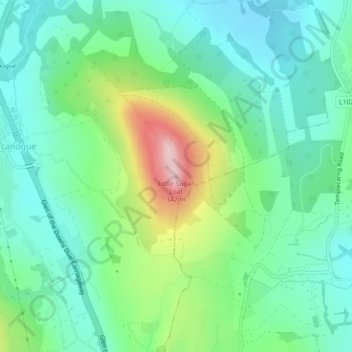
Name: Little Sugar Loaf topographic map, elevation, terrain.
Average elevation: 131 m
Minimum elevation: 53 m
Maximum elevation: 331 m
Make a donation
Other topographic maps
Click on a map to view its topography, its elevation and its terrain.
Roundwood
Roundwood, historisch auch als Togher bekannt, befindet sich am Kreuzungspunkt der Regionalstraßen R755, R764 und R765. Die R755 ist die Hauptverkehrsstrecke von Dublin in das südlich gelegene Glendalough in den Wicklow Mountains. Mit einer Seehöhe von 238 m ist Roundwood eines der höchstgelegenen Dörfer…
Average elevation: 242 m
Wicklow Mountains National Park
Das archäologische Denkmal liegt neben dem Upper Lake. Es ist ein steinernes ein Ringfort mit einer Trockenmauer von etwa 20 m Durchmesser, die etwa einen Meter Resthöhe hat. Cahers werden regional als Cathair, Cashel oder Dun und lage-, form- bzw. materialbezogen auch als Cliff-, Coastal-, Promontory-,…
Average elevation: 322 m
Make a donation