
Stoddard Hill topographic map
Interactive map
Click on the map to display elevation.
About this map
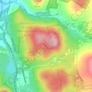
Name: Stoddard Hill topographic map, elevation, terrain.
Location: Stoddard Hill, Leverett, Franklin, Massachusetts, 01351, USA (42.50559 -72.51069 42.50569 -72.51059)
Average elevation: 178 m
Minimum elevation: 86 m
Maximum elevation: 287 m
Other topographic maps
Click on a map to view its topography, its elevation and its terrain.
Stacy Mountain
USA > Massachusetts > Leverett
Stacy Mountain, Leverett, Franklin, Massachusetts, 01351, USA
Average elevation: 209 m