
Thank you for supporting this site ❤️
Make a donation
Make a donation
Spring Hill topographic map
Click on the map to display elevation.
Thank you for supporting this site ❤️
Make a donation
Make a donation
About this map
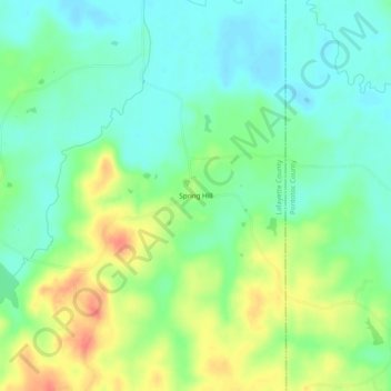
Name: Spring Hill topographic map, elevation, terrain.
Location: Spring Hill, Lafayette County, Mississippi, United States (34.17733 -89.27702 34.21733 -89.23702)
Average elevation: 124 m
Minimum elevation: 105 m
Maximum elevation: 157 m
Thank you for supporting this site ❤️
Make a donation
Make a donation
Other topographic maps
Click on a map to view its topography, its elevation and its terrain.