
Thank you for supporting this site ❤️
Make a donation
Make a donation
Gwer West topographic map
Click on the map to display elevation.
Thank you for supporting this site ❤️
Make a donation
Make a donation
About this map
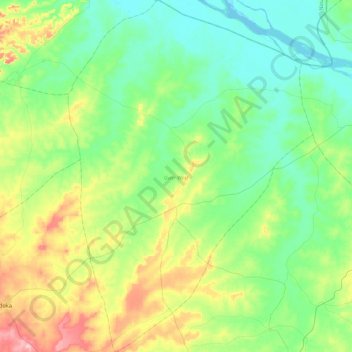
Name: Gwer West topographic map, elevation, terrain.
Location: Gwer West, Benue State, Nigeria (7.39264 8.06369 7.85317 8.38734)
Average elevation: 115 m
Minimum elevation: 58 m
Maximum elevation: 265 m
Thank you for supporting this site ❤️
Make a donation
Make a donation
Other topographic maps
Click on a map to view its topography, its elevation and its terrain.