
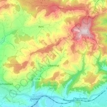
Oberthal topographic map
Interactive map
Click on the map to display elevation.
About this map
Name: Oberthal topographic map, elevation, terrain.
Average elevation: 870 m
Minimum elevation: 678 m
Maximum elevation: 1,114 m
Other topographic maps
Click on a map to view its topography, its elevation and its terrain.
Kehrsatz
Schweiz > Bern > Verwaltungskreis Bern-Mittelland
Kehrsatz, Verwaltungskreis Bern-Mittelland, Verwaltungsregion Bern-Mittelland, Bern, 3122, Schweiz
Average elevation: 600 m
Bern
Schweiz > Bern > Verwaltungskreis Bern-Mittelland
Bern, Verwaltungskreis Bern-Mittelland, Verwaltungsregion Bern-Mittelland, Bern, Schweiz
Average elevation: 612 m
Boll
Schweiz > Bern > Verwaltungskreis Bern-Mittelland
Boll, Vechigen, Verwaltungskreis Bern-Mittelland, Verwaltungsregion Bern-Mittelland, Bern, 3067, Schweiz
Average elevation: 672 m
Laupen
Schweiz > Bern > Verwaltungskreis Bern-Mittelland
Laupen, Verwaltungskreis Bern-Mittelland, Verwaltungsregion Bern-Mittelland, Bern, 3177, Schweiz
Average elevation: 531 m
Hötschigen
Schweiz > Bern > Verwaltungskreis Bern-Mittelland > Konolfingen > Hötschige
Hötschigen, Hötschige, Konolfingen, Verwaltungskreis Bern-Mittelland, Verwaltungsregion Bern-Mittelland, Bern, 3510, Schweiz
Average elevation: 763 m
Grafenried
Schweiz > Bern > Verwaltungskreis Bern-Mittelland
Grafenried, Fraubrunnen, Verwaltungskreis Bern-Mittelland, Verwaltungsregion Bern-Mittelland, Bern, 3312, Schweiz
Average elevation: 531 m
Rüeggisberg
Schweiz > Bern > Verwaltungskreis Bern-Mittelland
Rüeggisberg, Verwaltungskreis Bern-Mittelland, Verwaltungsregion Bern-Mittelland, Bern, Schweiz
Average elevation: 970 m
Muri bei Bern
Schweiz > Bern > Verwaltungskreis Bern-Mittelland
Muri bei Bern, Verwaltungskreis Bern-Mittelland, Verwaltungsregion Bern-Mittelland, Bern, Schweiz
Average elevation: 568 m
Neuenegg
Schweiz > Bern > Verwaltungskreis Bern-Mittelland
Neuenegg, Verwaltungskreis Bern-Mittelland, Verwaltungsregion Bern-Mittelland, Bern, 3176, Schweiz
Average elevation: 608 m
Gantrisch
Schweiz > Bern > Verwaltungskreis Bern-Mittelland > Rüeggisberg
Gantrisch, Rüeggisberg, Verwaltungskreis Bern-Mittelland, Verwaltungsregion Bern-Mittelland, Bern, Schweiz
Average elevation: 1,776 m
Habstetten
Schweiz > Bern > Verwaltungskreis Bern-Mittelland > Bolligen
Habstetten, Bolligen, Verwaltungskreis Bern-Mittelland, Verwaltungsregion Bern-Mittelland, Bern, 3065, Schweiz
Average elevation: 655 m
Wald (BE)
Schweiz > Bern > Verwaltungskreis Bern-Mittelland
Wald (BE), Verwaltungskreis Bern-Mittelland, Verwaltungsregion Bern-Mittelland, Bern, 3086, Schweiz
Average elevation: 785 m
Utzigen
Schweiz > Bern > Verwaltungskreis Bern-Mittelland > Boll
Utzigen, Boll, Vechigen, Verwaltungskreis Bern-Mittelland, Verwaltungsregion Bern-Mittelland, Bern, 3068, Schweiz
Average elevation: 733 m
Bantiger
Schweiz > Bern > Verwaltungskreis Bern-Mittelland > Bolligen
Bantiger, Bolligen, Verwaltungskreis Bern-Mittelland, Verwaltungsregion Bern-Mittelland, Bern, 3065, Schweiz
Average elevation: 764 m
Gurten
Schweiz > Bern > Verwaltungskreis Bern-Mittelland > Köniz
Gurten, Köniz, Verwaltungskreis Bern-Mittelland, Verwaltungsregion Bern-Mittelland, Bern, 3095, Schweiz
Average elevation: 677 m
Limpach
Schweiz > Bern > Verwaltungskreis Bern-Mittelland
Limpach, Fraubrunnen, Verwaltungskreis Bern-Mittelland, Verwaltungsregion Bern-Mittelland, Bern, 3312, Schweiz
Average elevation: 504 m
Riggisberg
Schweiz > Bern > Verwaltungskreis Bern-Mittelland
Riggisberg, Verwaltungskreis Bern-Mittelland, Verwaltungsregion Bern-Mittelland, Bern, 3132, Schweiz
Average elevation: 864 m
Oberbütschel
Schweiz > Bern > Verwaltungskreis Bern-Mittelland > Rüeggisberg
Oberbütschel, Rüeggisberg, Verwaltungskreis Bern-Mittelland, Verwaltungsregion Bern-Mittelland, Bern, 3088, Schweiz
Average elevation: 878 m
Oberdiessbach
Schweiz > Bern > Verwaltungskreis Bern-Mittelland
Oberdiessbach, Verwaltungskreis Bern-Mittelland, Verwaltungsregion Bern-Mittelland, Bern, 3672, Schweiz
Average elevation: 725 m
Bremgarten bei Bern
Schweiz > Bern > Verwaltungskreis Bern-Mittelland
Bremgarten bei Bern, Verwaltungskreis Bern-Mittelland, Verwaltungsregion Bern-Mittelland, Bern, 3047, Schweiz
Average elevation: 540 m
Schwarzenburg
Schweiz > Bern > Verwaltungskreis Bern-Mittelland
Schwarzenburg, Verwaltungskreis Bern-Mittelland, Verwaltungsregion Bern-Mittelland, Bern, Schweiz
Average elevation: 779 m
Jaberg
Schweiz > Bern > Verwaltungskreis Bern-Mittelland > Jaberg
Jaberg, Verwaltungskreis Bern-Mittelland, Verwaltungsregion Bern-Mittelland, Bern, 3629, Schweiz
Average elevation: 562 m
Sense
Schweiz > Bern > Verwaltungskreis Bern-Mittelland > Laupen
Sense, Thörishaus, Laupen, Verwaltungskreis Bern-Mittelland, Verwaltungsregion Bern-Mittelland, Bern, 3177, Schweiz
Average elevation: 704 m
Münsingen
Schweiz > Bern > Verwaltungskreis Bern-Mittelland
Münsingen, Verwaltungskreis Bern-Mittelland, Verwaltungsregion Bern-Mittelland, Bern, Schweiz
Average elevation: 625 m
Münchenbuchsee
Schweiz > Bern > Verwaltungskreis Bern-Mittelland
Münchenbuchsee, Verwaltungskreis Bern-Mittelland, Verwaltungsregion Bern-Mittelland, Bern, 3053, Schweiz
Average elevation: 569 m
Sense
Schweiz > Bern > Verwaltungskreis Bern-Mittelland > Kalchstätten > Gehlismatt
Sense, Gehlismatt, Kalchstätten, Guggisberg, Verwaltungskreis Bern-Mittelland, Verwaltungsregion Bern-Mittelland, Bern, 1719, Schweiz
Average elevation: 948 m
Konolfingen
Schweiz > Bern > Verwaltungskreis Bern-Mittelland
Konolfingen, Verwaltungskreis Bern-Mittelland, Verwaltungsregion Bern-Mittelland, Bern, Schweiz
Average elevation: 745 m
Rüschegg
Schweiz > Bern > Verwaltungskreis Bern-Mittelland
Rüschegg, Verwaltungskreis Bern-Mittelland, Verwaltungsregion Bern-Mittelland, Bern, Schweiz
Average elevation: 1,193 m