
Grabfeld topographic map
Interactive map
Click on the map to display elevation.
About this map
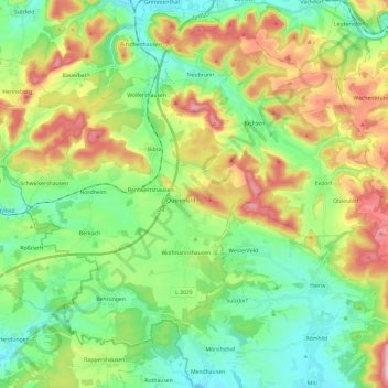
Name: Grabfeld topographic map, elevation, terrain.
Average elevation: 384 m
Minimum elevation: 291 m
Maximum elevation: 557 m
Other topographic maps
Click on a map to view its topography, its elevation and its terrain.
Oberhof
Duitsland > Thüringen > Landkreis Schmalkalden-Meiningen
Oberhof, Landkreis Schmalkalden-Meiningen, Thüringen, 98559, Duitsland
Average elevation: 749 m