
Manali topographic map
Interactive map
Click on the map to display elevation.
About this map
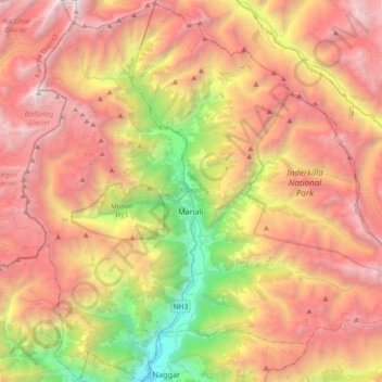
Name: Manali topographic map, elevation, terrain.
Location: Manali, Kullu, Himachal Pradesh, India (32.10806 77.02620 32.41518 77.39285)
Average elevation: 3,745 m
Minimum elevation: 1,459 m
Maximum elevation: 5,911 m
Other topographic maps
Click on a map to view its topography, its elevation and its terrain.
Sihunta
Sihunta, Chamba district, Himachal Pradesh, India
Average elevation: 1,343 m
Sarahan
India > Himachal Pradesh > Sarahan
Sarahan, Kullu, Himachal Pradesh, India
Average elevation: 2,519 m
Shimla
India > Himachal Pradesh > Shimla (urban)
Shimla, Shimla (urban), Shimla District, Himachal Pradesh, 171001, India
Average elevation: 1,557 m
Lahul and Spiti
Lahul and Spiti, Himachal Pradesh, India
Average elevation: 4,276 m
Great Himalayan National Park
Great Himalayan National Park, Kullu, Himachal Pradesh, India
Average elevation: 4,303 m
Kullu
India > Himachal Pradesh > Kullu
Kullu, Himachal Pradesh, 175100, India
Average elevation: 1,808 m
Pin Valley National Park
Pin Valley National Park, Lahul and Spiti, Himachal Pradesh, India
Average elevation: 4,903 m