
Thank you for supporting this site ❤️
Make a donation
Make a donation
Zoutleeuw topographic map
Click on the map to display elevation.
Thank you for supporting this site ❤️
Make a donation
Make a donation
About this map
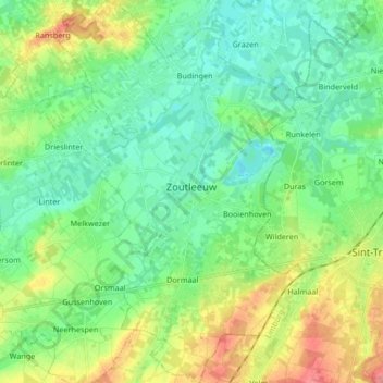
Name: Zoutleeuw topographic map, elevation, terrain.
Location: Zoutleeuw, Löwen, Flämisch-Brabant, Flandern, 3440, Belgien (50.77905 5.04340 50.88467 5.15233)
Average elevation: 43 m
Minimum elevation: 20 m
Maximum elevation: 92 m
Thank you for supporting this site ❤️
Make a donation
Make a donation
Other topographic maps
Click on a map to view its topography, its elevation and its terrain.