
Crawley topographic map
Click on the map to display elevation.
Crawley
Crawley lies within the Sussex Weald, an area of highly variable terrain so that many microclimates of frost hollows, sun traps and windswept hilltops will be encountered over a short distance. During calm, clear periods of weather this allows for some interesting temperature variations, although most of the time, when mobile westerly airstreams persist, the weather is typically Oceanic like the rest of the British Isles. Gatwick is the nearest weather station that publishes long-term averages that give an accurate description of the climate of the Crawley area, although more recently the Met Office has also published data for its nearby weather station at Charlwood. Both weather stations are about 3 miles north of Crawley town centre and at similar altitudes.
About this map
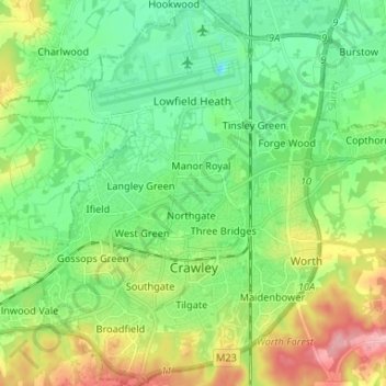
Name: Crawley topographic map, elevation, terrain.
Location: Crawley, West Sussex, England, United Kingdom (51.08481 -0.25563 51.16730 -0.13298)
Average elevation: 80 m
Minimum elevation: 39 m
Maximum elevation: 165 m
Other topographic maps
Click on a map to view its topography, its elevation and its terrain.
Brook Street
United Kingdom > England > West Sussex > Mid Sussex > Whitemans Green
Average elevation: 76 m
Gay Street
United Kingdom > England > West Sussex > Horsham > West Chiltington
Average elevation: 38 m
Washington Common
United Kingdom > England > West Sussex > Storrington > Washington
Average elevation: 61 m
Felbridge
United Kingdom > England > West Sussex > Mid Sussex > East Grinstead
Average elevation: 98 m
Twineham Green
United Kingdom > England > West Sussex > Mid Sussex > Hickstead
Average elevation: 21 m
Ardingly Reservoir
United Kingdom > England > West Sussex > Mid Sussex > Ardingly
Average elevation: 98 m
Batchelors Farm Nature Conservation Site
United Kingdom > England > West Sussex > Mid Sussex District > Burgess Hill
Average elevation: 49 m
Henry Burt Wood
United Kingdom > England > West Sussex > Mid Sussex > Burgess Hill
Average elevation: 39 m
Sullington Warren
United Kingdom > England > West Sussex > Horsham > Storrington
Average elevation: 54 m
Worth Abbey
United Kingdom > England > West Sussex > Mid Sussex > Turners Hill
Average elevation: 124 m
Donnington Park
United Kingdom > England > West Sussex > Chichester > Donnington
Average elevation: 8 m
Smock Alley
United Kingdom > England > West Sussex > Horsham > West Chiltington Common
Average elevation: 38 m