
Thank you for supporting this site ❤️
Make a donation
Make a donation
Kliening topographic map
Click on the map to display elevation.
Thank you for supporting this site ❤️
Make a donation
Make a donation
About this map
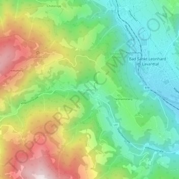
Name: Kliening topographic map, elevation, terrain.
Average elevation: 968 m
Minimum elevation: 674 m
Maximum elevation: 1,448 m
Thank you for supporting this site ❤️
Make a donation
Make a donation
Other topographic maps
Click on a map to view its topography, its elevation and its terrain.
Katastralgemeinde Kliening
Österreich > Kärnten > Bezirk Wolfsberg > Bad Sankt Leonhard im Lavanttal
Average elevation: 1,029 m