
Make a donation
Mont Blanc massif topographic map
Click on the map to display elevation.
Make a donation
Mont Blanc massif
The Mont Blanc massif (French: Massif du Mont-Blanc; Italian: Massiccio del Monte Bianco) is a mountain range in the Alps, located mostly in France and Italy, but also straddling Switzerland at its northeastern end. It contains eleven major independent summits, each over 4,000 metres (13,123 ft) in height. It is named after Mont Blanc (4,808 metres (15,774 ft)), the highest point in western Europe and the European Union. Because of its considerable overall altitude, a large proportion of the massif is covered by glaciers, which include the Mer de Glace and the Miage Glacier – the longest glaciers in France and Italy, respectively.
Make a donation
About this map
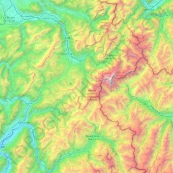
Name: Mont Blanc massif topographic map, elevation, terrain.
Average elevation: 2,011 m
Minimum elevation: 497 m
Maximum elevation: 4,798 m
Make a donation
Other topographic maps
Click on a map to view its topography, its elevation and its terrain.
Pointe de Chardonnière
France > Auvergne-Rhône-Alpes > Upper Savoy > Sixt-Fer-à-Cheval
Average elevation: 2,128 m