
Bundibugyo Town Council topographic map
Interactive map
Click on the map to display elevation.
About this map
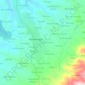
Name: Bundibugyo Town Council topographic map, elevation, terrain.
Location: Bundibugyo Town Council, Bundibugyo, Western Region, Ouganda (0.68135 30.05047 0.72963 30.08011)
Average elevation: 969 m
Minimum elevation: 798 m
Maximum elevation: 1,533 m
Other topographic maps
Click on a map to view its topography, its elevation and its terrain.
Rwenzori;chaîne du Rwenzori;monts Rwenzori
Ouganda > Bundibugyo > Sindila
Rwenzori;chaîne du Rwenzori;monts Rwenzori, Sindila, Bundibugyo, Western Region, Ouganda
Average elevation: 1,570 m