
Reti Bandar topographic map
Click on the map to display elevation.
About this map
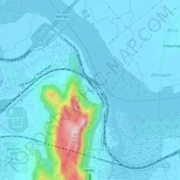
Name: Reti Bandar topographic map, elevation, terrain.
Average elevation: 29 m
Minimum elevation: -2 m
Maximum elevation: 298 m
Other topographic maps
Click on a map to view its topography, its elevation and its terrain.
Sanjay Gandhi National Park
India > Maharashtra > Thane Taluka > Thane
The region is hilly with elevations between 30 and 480 m (98 and 1,575 ft). Vihar Lake and Tulsi Lake in the park meet a part of the city's water requirements. The park is said to be the lungs of the city as it purifies much of the air pollution in the city.
Average elevation: 42 m