
Thank you for supporting this site ❤️
Make a donation
Make a donation
King Mountain topographic map
Click on the map to display elevation.
Thank you for supporting this site ❤️
Make a donation
Make a donation
About this map
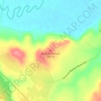
Name: King Mountain topographic map, elevation, terrain.
Location: King Mountain, Coryell County, Texas, 76526, United States (31.32484 -97.62785 31.32494 -97.62775)
Average elevation: 240 m
Minimum elevation: 204 m
Maximum elevation: 293 m
Thank you for supporting this site ❤️
Make a donation
Make a donation
Other topographic maps
Click on a map to view its topography, its elevation and its terrain.