
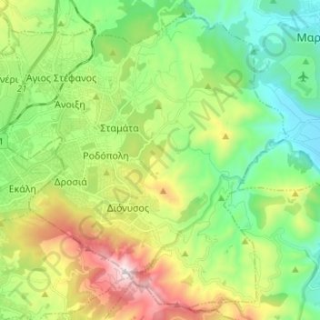
Municipality of Dionysos topographic map
Interactive map
Click on the map to display elevation.
About this map
Name: Municipality of Dionysos topographic map, elevation, terrain.
Average elevation: 385 m
Minimum elevation: 21 m
Maximum elevation: 1,098 m
Other topographic maps
Click on a map to view its topography, its elevation and its terrain.
Αρχή
Greece > Attica > Regional Unit of East Attica
Αρχή, Regional Unit of East Attica, Attica, Greece
Average elevation: 15 m
Gerakas Municipal Unit
Greece > Attica > Regional Unit of East Attica > Gerakas Municipal Unit
Gerakas Municipal Unit, Municipality of Pallini, Regional Unit of East Attica, Attica, 15344, Greece
Average elevation: 259 m
Marathon
Greece > Attica > Regional Unit of East Attica
Marathon, Municipality of Marathonas, Regional Unit of East Attica, Attica, 190 07, Greece
Average elevation: 146 m