
Make a donation
Columbia Plateau topographic map
Click on the map to display elevation.
Make a donation
About this map
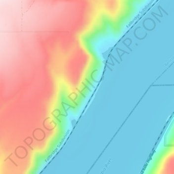
Name: Columbia Plateau topographic map, elevation, terrain.
Location: Columbia Plateau, Benton County, Washington, United States (45.99953 -119.00144 45.99963 -119.00134)
Average elevation: 221 m
Minimum elevation: 102 m
Maximum elevation: 417 m
Make a donation
Other topographic maps
Click on a map to view its topography, its elevation and its terrain.
Kennewick
United States > Washington > Benton County
Native Americans populated the area around modern-day Kennewick for millennia before being discovered and settled by European descendants. These inhabitants consisted of people from the Umatilla, Wanapum, Nez Perce, and Yakama tribes. Kennewick's low elevation helped to moderate winter temperatures. On top of…
Average elevation: 157 m
Richland
United States > Washington > Benton County
According to the United States Census Bureau, the city has a total area of 39.11 square miles (101.29 km2), of which, 35.72 square miles (92.51 km2) is land and 3.39 square miles (8.78 km2) is water. Elevation at the airport is 120 m (390 ft).
Average elevation: 164 m
Make a donation
Kennewick
United States > Washington > Benton County
Native Americans populated the area around modern-day Kennewick for millennia before being discovered and settled by European descendants. These inhabitants consisted of people from the Umatilla, Wanapum, Nez Perce, and Yakama tribes. Kennewick's low elevation helped to moderate winter temperatures. On top of…
Average elevation: 157 m
West Richland
United States > Washington > Benton County
The original people of the region were the Chemnapum Indians (closely related to the Wanapum tribe), living near the mouth of the Yakima River. Lewis and Clark passed through the area in 1805, and an expedition of the Army Corps of Topographical Engineers headed by Robert E Johnson mapped the Yakima Valley in…
Average elevation: 146 m
Make a donation
Richland
United States > Washington > Benton County
According to the United States Census Bureau, the city has a total area of 39.11 square miles (101.29 km2), of which, 35.72 square miles (92.51 km2) is land and 3.39 square miles (8.78 km2) is water. Elevation at the airport is 120 m (390 ft).
Average elevation: 164 m
Make a donation
West Richland
United States > Washington > Benton County
The original people of the region were the Chemnapum Indians (closely related to the Wanapum tribe), living near the mouth of the Yakima River. Lewis and Clark passed through the area in 1805, and an expedition of the Army Corps of Topographical Engineers headed by Robert E Johnson mapped the Yakima Valley in…
Average elevation: 146 m
Kennewick
United States > Washington > Benton County
Native Americans populated the area around modern-day Kennewick for millennia before being discovered and settled by European descendants. These inhabitants consisted of people from the Umatilla, Wanapum, Nez Perce, and Yakama tribes. Kennewick's low elevation helped to moderate winter temperatures. On top of…
Average elevation: 157 m