
Thank you for supporting this site ❤️
Make a donation
Make a donation
Edderitz topographic map
Click on the map to display elevation.
Thank you for supporting this site ❤️
Make a donation
Make a donation
Edderitz
Die zwischen Edderitz und Baasdorf gelegene Pilsenhöhe ist mit 111 Metern die höchste Erhebung im Gebiet der Einheitsgemeinde Stadt Südliches Anhalt.
Thank you for supporting this site ❤️
Make a donation
Make a donation
About this map
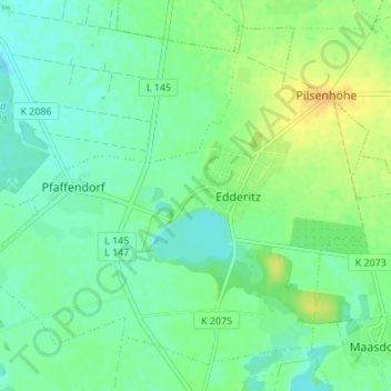
Name: Edderitz topographic map, elevation, terrain.
Average elevation: 90 m
Minimum elevation: 79 m
Maximum elevation: 108 m
Thank you for supporting this site ❤️
Make a donation
Make a donation
Other topographic maps
Click on a map to view its topography, its elevation and its terrain.
Thank you for supporting this site ❤️
Make a donation
Make a donation
Thank you for supporting this site ❤️
Make a donation
Make a donation
Osternienburg
Deutschland > Sachsen-Anhalt > Anhalt-Bitterfeld > Osternienburger Land
Average elevation: 70 m
Thank you for supporting this site ❤️
Make a donation
Make a donation
Thank you for supporting this site ❤️
Make a donation
Make a donation