
Make a donation
Engelburg topographic map
Click on the map to display elevation.
Make a donation
About this map
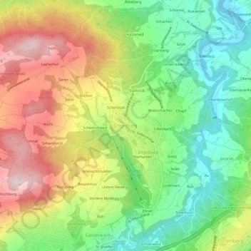
Name: Engelburg topographic map, elevation, terrain.
Average elevation: 700 m
Minimum elevation: 535 m
Maximum elevation: 913 m
Make a donation
Other topographic maps
Click on a map to view its topography, its elevation and its terrain.
St. Gallen
Switzerland > St. Gallen > Wahlkreis St. Gallen
St. Gallen is notable for reporting the highest maximum radioactivity measurements of any Swiss city, as published in the 2009 yearly report by the Federal Office of Public Health. While the daily average level of gamma-ray radioactivity in the city is unremarkable at 105 nSv/h, the maximum can reach 195…
Average elevation: 740 m
St. Gallen
Switzerland > St. Gallen > Wahlkreis St. Gallen
St. Gallen is notable for reporting the highest maximum radioactivity measurements of any Swiss city, as published in the 2009 yearly report by the Federal Office of Public Health. While the daily average level of gamma-ray radioactivity in the city is unremarkable at 105 nSv/h, the maximum can reach 195…
Average elevation: 741 m
St. Gallen
Switzerland > St. Gallen > Wahlkreis St. Gallen
St. Gallen is notable for reporting the highest maximum radioactivity measurements of any Swiss city, as published in the 2009 yearly report by the Federal Office of Public Health. While the daily average level of gamma-ray radioactivity in the city is unremarkable at 105 nSv/h, the maximum can reach 195…
Average elevation: 740 m
St. Gallen
Switzerland > St. Gallen > Wahlkreis St. Gallen
St. Gallen is notable for reporting the highest maximum radioactivity measurements of any Swiss city, as published in the 2009 yearly report by the Federal Office of Public Health. While the daily average level of gamma-ray radioactivity in the city is unremarkable at 105 nSv/h, the maximum can reach 195…
Average elevation: 740 m
Make a donation