
Thank you for supporting this site ❤️
Make a donation
Make a donation
Manton topographic map
Click on the map to display elevation.
Thank you for supporting this site ❤️
Make a donation
Make a donation
About this map
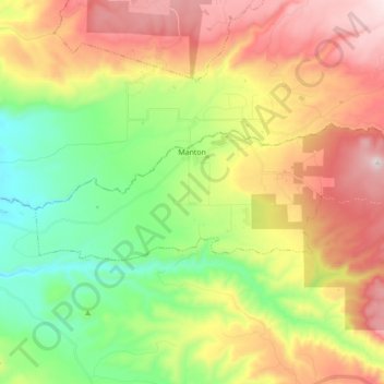
Name: Manton topographic map, elevation, terrain.
Location: Manton, Tehama County, California, United States (40.39779 -121.94115 40.44498 -121.76692)
Average elevation: 722 m
Minimum elevation: 352 m
Maximum elevation: 1,207 m
Thank you for supporting this site ❤️
Make a donation
Make a donation
Other topographic maps
Click on a map to view its topography, its elevation and its terrain.
Paskenta
United States > California > Tehama County
Paskenta (Wintun: Paskenti) is a small unincorporated town in Tehama County, California. Historically, it had greater local importance due to the presence of an active lumber mill. The ZIP Code is 96074. The community is inside area code 530 and the Paskenta CDP. Paskenta sits at an elevation of 725 feet (221…
Average elevation: 268 m
Thank you for supporting this site ❤️
Make a donation
Make a donation