
Thank you for supporting this site ❤️
Make a donation
Make a donation
Le Recoux topographic map
Click on the map to display elevation.
Thank you for supporting this site ❤️
Make a donation
Make a donation
About this map
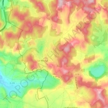
Name: Le Recoux topographic map, elevation, terrain.
Average elevation: 886 m
Minimum elevation: 740 m
Maximum elevation: 1,015 m
Thank you for supporting this site ❤️
Make a donation
Make a donation
Other topographic maps
Click on a map to view its topography, its elevation and its terrain.
La Baraque de Trémolet
France > Occitanie > Lozère > Massegros Causses Gorges
Average elevation: 855 m
Les Vignes
France > Occitanie > Lozère > Massegros Causses Gorges
Le village est construit au bord du Tarn, sur les flancs du plateau calcaire du causse de Sauveterre, face au causse Méjean, à environ 400 m d'altitude.
Average elevation: 778 m
Thank you for supporting this site ❤️
Make a donation
Make a donation
Thank you for supporting this site ❤️
Make a donation
Make a donation