Geolocate

Prenzlauer Berg topographic map

Interactive map

Click on the map to display elevation.

About this map

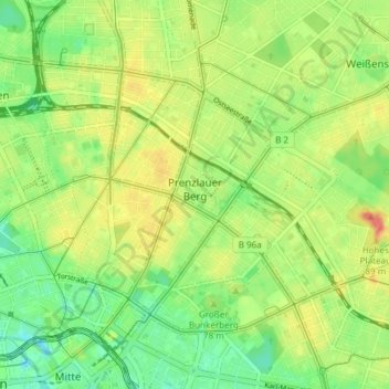
Name: Prenzlauer Berg topographic map, elevation, terrain.

Location: Prenzlauer Berg, Pankow, Berlin, Allemagne (52.51993 13.39685 52.55859 13.47211)

Average elevation: 51 m

Minimum elevation: 29 m

Maximum elevation: 74 m

Other topographic maps

Click on a map to view its topography, its elevation and its terrain.

Berlin

Allemagne > Berlin > Berlin

Berlin, 10117, Allemagne

Average elevation: 47 m

Rehwiese

Allemagne > Berlin

Rehwiese, Nikolassee, Steglitz-Zehlendorf, Berlin, 14129, Allemagne

Average elevation: 44 m

Vinetaplatz

Allemagne > Berlin

Vinetaplatz, Gesundbrunnen, Mitte, Berlin, 13355, Allemagne

Average elevation: 50 m

Vikunas

Allemagne > Berlin

Vikunas, Hardenbergplatz, Charlottenburg, Charlottenburg-Wilmersdorf, Berlin, 10623, Allemagne

Average elevation: 40 m

Lichtenberg

Allemagne > Berlin > Berlin

Lichtenberg, Berlin, Allemagne

Average elevation: 50 m