
Sainzelles topographic map
Interactive map
Click on the map to display elevation.
About this map
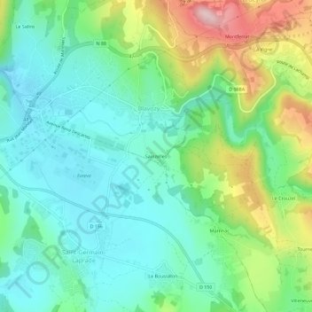
Name: Sainzelles topographic map, elevation, terrain.
Average elevation: 729 m
Minimum elevation: 654 m
Maximum elevation: 904 m
Other topographic maps
Click on a map to view its topography, its elevation and its terrain.
Le Salins
France > Auvergne-Rhône-Alpes > Haute-Loire > Blavozy
Le Salins, Blavozy, Le Puy-en-Velay, Haute-Loire, Auvergne-Rhône-Alpes, France métropolitaine, 43700, France
Average elevation: 739 m