
Thank you for supporting this site ❤️
Make a donation
Make a donation
Tafers topographic map
Click on the map to display elevation.
Thank you for supporting this site ❤️
Make a donation
Make a donation
About this map
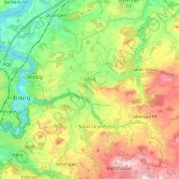
Name: Tafers topographic map, elevation, terrain.
Location: Tafers, Sensebezirk, Freiburg, 1712, Schweiz (46.76379 7.18057 46.85568 7.32089)
Average elevation: 694 m
Minimum elevation: 528 m
Maximum elevation: 936 m
Thank you for supporting this site ❤️
Make a donation
Make a donation
Other topographic maps
Click on a map to view its topography, its elevation and its terrain.
Oberschrot
Schweiz > Freiburg > Sensebezirk
Die Fläche des 5,3 km² grossen ehemaligen Gemeindegebiets umfasst einen Abschnitt der voralpinen Hügellandschaft. Der zentrale Teil des Ortes wird von einer Talfurche eingenommen, welche das Tal der Ärgera im Westen mit demjenigen der Sense im Osten verbindet. Diese Talmulde wird vom Dütschbach gegen…
Average elevation: 901 m