
Thank you for supporting this site ❤️
Make a donation
Make a donation
Rehme topographic map
Click on the map to display elevation.
Thank you for supporting this site ❤️
Make a donation
Make a donation
About this map
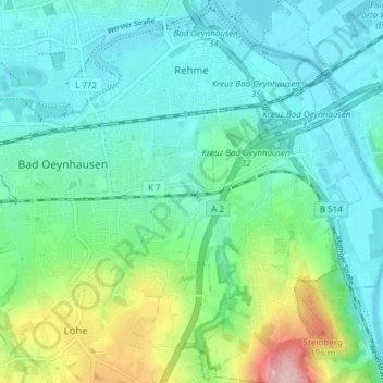
Name: Rehme topographic map, elevation, terrain.
Average elevation: 86 m
Minimum elevation: 41 m
Maximum elevation: 238 m
Thank you for supporting this site ❤️
Make a donation
Make a donation
Other topographic maps
Click on a map to view its topography, its elevation and its terrain.
Babbenhausen
Duitsland > Noordrijn-Westfalen > Kreis Minden-Lübbecke > Bad Oeynhausen
Average elevation: 83 m