
Thank you for supporting this site ❤️
Make a donation
Make a donation
Dietzen topographic map
Click on the map to display elevation.
Thank you for supporting this site ❤️
Make a donation
Make a donation
About this map
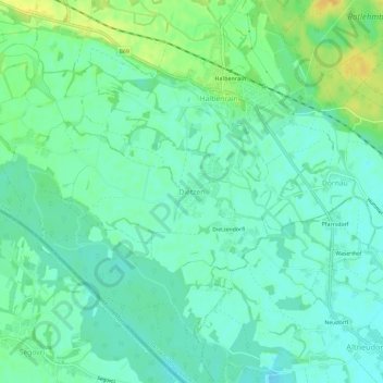
Name: Dietzen topographic map, elevation, terrain.
Average elevation: 216 m
Minimum elevation: 207 m
Maximum elevation: 234 m
Thank you for supporting this site ❤️
Make a donation
Make a donation
Other topographic maps
Click on a map to view its topography, its elevation and its terrain.
Bad Radkersburg
Österreich > Steiermark > Bezirk Südoststeiermark
Die Stadt liegt auf einer Höhe von 208 m an der Mur, welche die Staatsgrenze zu Slowenien bildet. Die Gemeinde (Bad Radkersburg 216 ha, Radkersburg Umgebung 2.783 ha) bedeckt eine Fläche von 29,94 km². Der ehemalige Südteil der Stadt ist seit 1919 Teil von Gornja Radgona in Slowenien.
Average elevation: 221 m
Thank you for supporting this site ❤️
Make a donation
Make a donation