
Thank you for supporting this site ❤️
Make a donation
Make a donation
Nestindar topographic map
Click on the map to display elevation.
Thank you for supporting this site ❤️
Make a donation
Make a donation
About this map
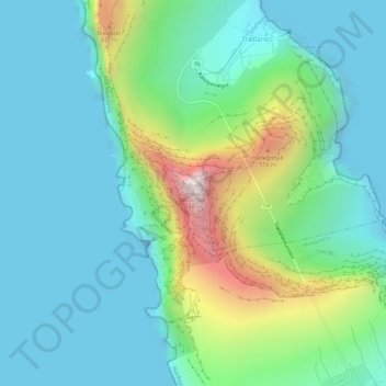
Name: Nestindar topographic map, elevation, terrain.
Location: Nestindar, Trøllanes, Norðoya sýsla, 798, Færøerne (62.35037 -6.79854 62.35047 -6.79844)
Average elevation: 175 m
Minimum elevation: -26 m
Maximum elevation: 754 m
Thank you for supporting this site ❤️
Make a donation
Make a donation