
Thank you for supporting this site ❤️
Make a donation
Make a donation
Borgin topographic map
Click on the map to display elevation.
Thank you for supporting this site ❤️
Make a donation
Make a donation
About this map
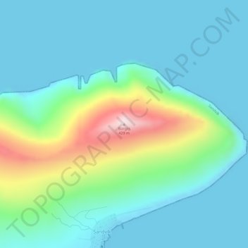
Name: Borgin topographic map, elevation, terrain.
Location: Borgin, Sandvík, Suðuroyar sýsla, 860, Færøerne (61.64458 -6.92401 61.64468 -6.92391)
Average elevation: 90 m
Minimum elevation: -1 m
Maximum elevation: 416 m
Thank you for supporting this site ❤️
Make a donation
Make a donation