
Make a donation
Häverstädt topographic map
Click on the map to display elevation.
Make a donation
About this map
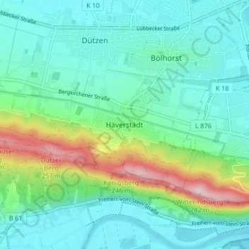
Name: Häverstädt topographic map, elevation, terrain.
Average elevation: 91 m
Minimum elevation: 37 m
Maximum elevation: 264 m
Make a donation
Other topographic maps
Click on a map to view its topography, its elevation and its terrain.
Minderheide
Deutschland > Nordrhein-Westfalen > Kreis Minden-Lübbecke > Minden
Average elevation: 59 m
Kutenhausen
Deutschland > Nordrhein-Westfalen > Kreis Minden-Lübbecke > Minden
Average elevation: 58 m
Päpinghausen
Deutschland > Nordrhein-Westfalen > Kreis Minden-Lübbecke > Minden
Average elevation: 48 m
Make a donation
Todtenhausen
Deutschland > Nordrhein-Westfalen > Kreis Minden-Lübbecke > Minden
1649 kam die „Bauerschaft Todtenhausen“ zu Brandenburg-Preußen (Huldigung des Großen Kurfürsten im Jahre 1650 im Schloss zu Petershagen). Die 1682 bestehenden 41 Höfe wurden nach der Höhe ihrer Ablieferungspflicht fortlaufend nummeriert. Daraus entstanden die ersten Hausnummern. Todtenhausen war dem…
Average elevation: 55 m
Make a donation
Bärenkämpen
Deutschland > Nordrhein-Westfalen > Kreis Minden-Lübbecke > Minden
Average elevation: 59 m