
Eastern Ghats topographic map
Interactive map
Click on the map to display elevation.
About this map
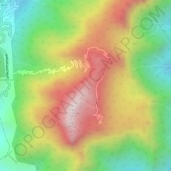
Name: Eastern Ghats topographic map, elevation, terrain.
Location: Eastern Ghats, Ramagiri, Gajapati, Odisha, India (18.97015 84.36691 18.97025 84.36701)
Average elevation: 1,130 m
Minimum elevation: 777 m
Maximum elevation: 1,494 m
North of the Palar River in Andhra Pradesh, the central portion of the Eastern Ghats consists of two parallel ranges running approximately north-south. The lower Velikonda Range lies to the east, and the higher Palikonda-Lankamalla-Nallamala Ranges lie to the west. They run in a nearly north-south alignment, parallel to the Coromandel Coast for close to 430 km between the Krishna and Pennar rivers. Its northern boundaries are marked by the flat Palnadu basin, while in the south it merges with the Tirupati hills. An extremely old system, the hills have been extensively weathered and eroded over the years. The average elevation today is about 520 m, but reaches 1,100 m at Bhairani Konda and 1,048 m at Gundla Brahmeswara.
Other topographic maps
Click on a map to view its topography, its elevation and its terrain.
Daringbadi
Daringbadi, Kandhamal District, Odisha, 762104, India
Average elevation: 758 m
Ward 41
India > Odisha > Bhubaneswar Municipal Corporation
Ward 41, South East Zone, Bhubaneswar Municipal Corporation, Khordha, Odisha, India
Average elevation: 39 m