
Thank you for supporting this site ❤️
Make a donation
Make a donation
Daringbadi topographic map
Click on the map to display elevation.
Thank you for supporting this site ❤️
Make a donation
Make a donation
About this map
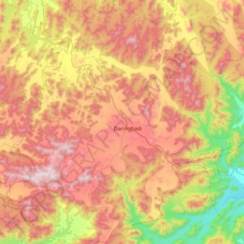
Name: Daringbadi topographic map, elevation, terrain.
Location: Daringbadi, Kandhamal District, Odisha, 762104, India (19.75426 83.95280 20.07818 84.28023)
Average elevation: 758 m
Minimum elevation: 151 m
Maximum elevation: 1,315 m
Thank you for supporting this site ❤️
Make a donation
Make a donation
Other topographic maps
Click on a map to view its topography, its elevation and its terrain.
Angul
India > Odisha > Anugul > Angul
Angul (Odia: ଅନୁଗୋଳ; also known as Anugul) is a town and a municipality and the headquarters of Angul district in the state of Odisha, India. Angul has an average elevation of 195 m (640 ft) above sea level. The total geographical area of the district is 6232 km2. From the point of view of area, it…
Average elevation: 121 m