
Thank you for supporting this site ❤️
Make a donation
Make a donation
Gateira topographic map
Click on the map to display elevation.
Thank you for supporting this site ❤️
Make a donation
Make a donation
About this map
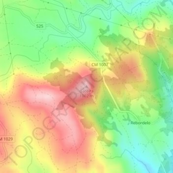
Name: Gateira topographic map, elevation, terrain.
Location: Gateira, Montalegre, Vila Real, 5470-065, Portugal (41.74668 -7.72362 41.74678 -7.72352)
Average elevation: 887 m
Minimum elevation: 778 m
Maximum elevation: 1,001 m
Thank you for supporting this site ❤️
Make a donation
Make a donation
Other topographic maps
Click on a map to view its topography, its elevation and its terrain.