
Thank you for supporting this site ❤️
Make a donation
Make a donation
Δίον topographic map
Click on the map to display elevation.
Thank you for supporting this site ❤️
Make a donation
Make a donation
About this map
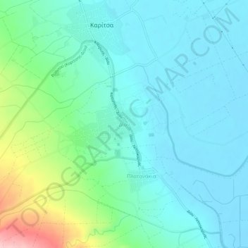
Name: Δίον topographic map, elevation, terrain.
Average elevation: 40 m
Minimum elevation: -3 m
Maximum elevation: 187 m
Thank you for supporting this site ❤️
Make a donation
Make a donation
Other topographic maps
Click on a map to view its topography, its elevation and its terrain.
Katerini Municipality
Greece > Central Macedonia > Pieria Regional Unit
Katerini (Greek: Κατερίνη, romanized: Kateríni, pronounced [kateˈrini]) is a city and a municipality in northern Greece. It is the capital of the Pieria regional unit in Central Macedonia. It lies on the Pierian plain, between Mount Olympus and the Thermaikos Gulf, at an altitude of 14 m. The…
Average elevation: 333 m
Dion - Olympos Municipality
Greece > Central Macedonia > Pieria Regional Unit
Average elevation: 629 m
Dion - Olympos Municipality
Greece > Central Macedonia > Pieria Regional Unit
Average elevation: 629 m
Thank you for supporting this site ❤️
Make a donation
Make a donation