
Thank you for supporting this site ❤️
Make a donation
Make a donation
Dion - Olympos Municipality topographic map
Click on the map to display elevation.
Thank you for supporting this site ❤️
Make a donation
Make a donation
About this map
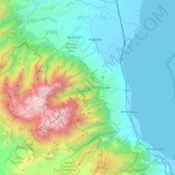
Name: Dion - Olympos Municipality topographic map, elevation, terrain.
Average elevation: 629 m
Minimum elevation: -2 m
Maximum elevation: 2,889 m
Thank you for supporting this site ❤️
Make a donation
Make a donation
Other topographic maps
Click on a map to view its topography, its elevation and its terrain.
Λιτόχωρο
Greece > Central Macedonia > Pieria Regional Unit
At an altitude of 850 m, beside the Enipeas gorge, Saint Dionysios built a monastery. Founded 1542, its name was Agia Triada, what means Holy Trinity, later changed to the name of the Saint. Plundered and burned several times in its history, it received the final blow from German troops in April 1943.
Average elevation: 396 m
Thank you for supporting this site ❤️
Make a donation
Make a donation