
Thank you for supporting this site ❤️
Make a donation
Make a donation
Manongarivo-Besely topographic map
Click on the map to display elevation.
Thank you for supporting this site ❤️
Make a donation
Make a donation
About this map
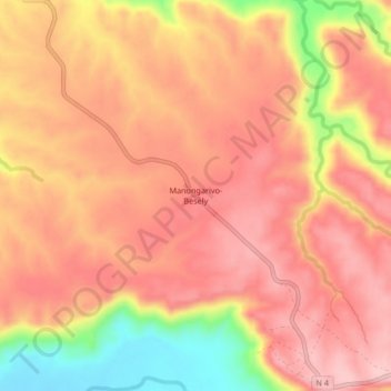
Name: Manongarivo-Besely topographic map, elevation, terrain.
Location: Manongarivo-Besely, Boeny, Province de Mahajanga, Madagascar (-15.88784 46.51154 -15.84784 46.55154)
Average elevation: 146 m
Minimum elevation: 25 m
Maximum elevation: 203 m
Thank you for supporting this site ❤️
Make a donation
Make a donation
Other topographic maps
Click on a map to view its topography, its elevation and its terrain.